

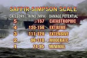
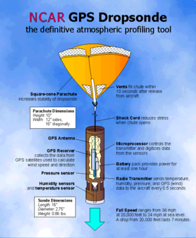
Dr. Hugh Willoughby, of Florida International University, was one of the first meteorologists to ever fly into the eye of a hurricane. Now the job is done by the Hurricane Hunters—a team of pilots, navigators and meteorologists who fly into these dangerous storms to help keep us safe. Here’s what I learned when I interviewed Hugh Willoughby: What is a hurricane eye? Hurricanes are circular storms so the wind blows around in a circle. The eye is the center of a hurricane. If a circular storm doesn’t have an eye, it is not a hurricane—it’s a tropical storm. The eye is surrounded by a ring of clouds called the eyewall. Within the eye, there is a calm area that is cloudless all the way up to space. The winds are strongest just at the inner edge of the eyewall, which is composed of violent thunderstorms with strong updrafts and downdrafts. The hurricane pinwheels out from the eyewall as spiral bands of wind and rain, which stretch for miles. When a hurricane’s eye passes over land, the storm suddenly stops and the sun comes out. But the relief is short-lived as the other side of the storm soon slams into the area. How do Hurricane Hunters help us? Hurricane Hunters fly into the eye of hurricanes that are heading towards our shores to help predict where the storm will make landfall. On every mission they must find the center of the storm at least twice and at most four times over a period of several hours because the change in position of the center of the eye tells us the direction the storm is moving and how fast it is moving. They also drop packages called dropsondes that contain measuring instruments for air pressure, humidity, and wind speed at the eyewall. These measurements tell us the destructive power of the storm or its “category.” During a hurricane season (from June 1 to November 30) the Hurricane Hunters and their fleet of ten airplanes can get data on three storms, twice a day. So flying into a hurricane’s eye is pretty routine for them. Is it dangerous? The planes can easily handle changes in air pressure and wind speeds that create “bumps” and it can be pretty bumpy going through the eyewall. But, in more than sixty years there have been only four accidents. All on board agree that the view of the eyewall from inside the eye is worth it! The plane has transported them inside nature’s most magnificent amphitheater. (c) Vicki Cobb 2014 Harvey and Irma have alerted everyone to the dangers of a hurricane. We can predict the course of a hurricane by flying into a hurricane and repeatedly measuring wind speed, humidity, air pressure, and temperature. Here's a video that will give you a taste of what it looks like as you approach an eye wall. It is filmed from a plane penetrating Hurricane Katrina. 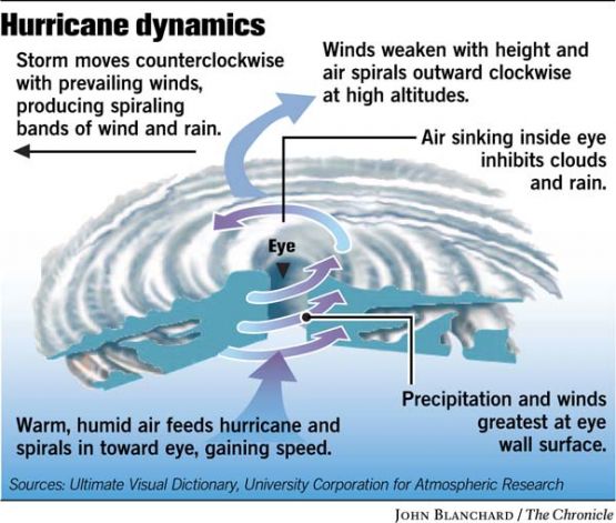
 MLA 8 Citation Cobb, Vicki. "Flying into the Eye of a Storm." Nonfiction Minute, iNK Think Tank, 18 Sept. 2017, www.nonfictionminute.org/the-nonfiction-minute/ flying-into-the-eye-of-a-storm.
2 Comments
 Sneed B. Collard III
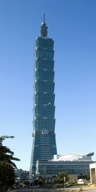
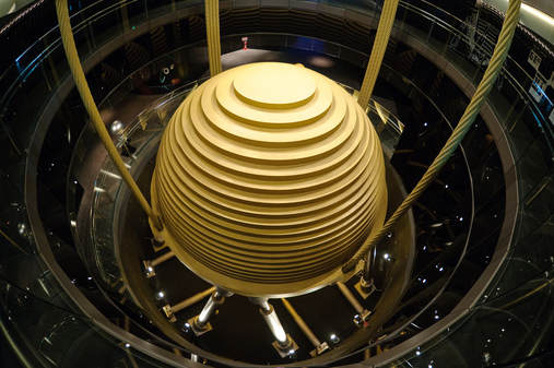
Several years ago, I rode the world’s fastest elevator to the top of one of the world’s tallest buildings—Taipei 101. Shaped like an elegant stalk of bamboo, Taipei 101 soars 1670 feet above the island nation of Taiwan. However, the engineers who designed the building faced two monumental challenges. The first is that dozens of earthquakes shake Taiwan each year. The second is that in an average year, Taiwan gets hammered by three or four hurricanes, or typhoons. How, engineers wondered, could they keep people comfortable inside Taipei 101 when it swayed back and forth? More important, how could they keep the building from getting damaged or collapsing in a massive earthquake or 100 mile-per-hour winds? One solution: a damper ball. Damping devices are weighty objects that can reduce the motion of a bridge, building, or other structure. In the case of Taipei 101, engineers placed the damper ball near the top of the building—the part that sways the most. The ball is hung from thick cables inside the building and rests on giant springs or “dampers.” One of Isaac Newton’s basic laws of physics is that an object at rest tends to stay at rest—and the damper ball proves it. Every time Taipei 101 starts swaying, the damper ball wants to stay where it is and “pulls back” on the building, reducing how far the building moves. When the building sways in the opposite direction, the process repeats itself—but in the reverse direction. Of course the building also pulls on the damper ball, but the ball’s movements are restricted by the dampers it presses against. Does the system work? You bet. The damper ball inside of Taipei 101 reduces the building’s movement by 30 to 40 percent! Of course not just any damping device could protect an enormous building like Taipei 101. Taipei’s damper ball weighs 1.5 million pounds—as much as two fully-loaded jumbo jets. It is composed of 41 circular steel plates that stand taller than a one-story house. In 2008, when a giant earthquake hit mainland China, the people of Taiwan could feel it hundreds of miles away. The damper ball did its job, resisting Taipei 101’s movement, keeping the building safe. During Typhoon Soudelor in 2015, the damper again worked like a charm, protecting the building against 100- to 145-mile-per-hour winds. Besides protecting Taipei 101, the damper ball has become a major tourist attraction. Each year, thousands of visitors ride to the 89th floor. They take selfies next to the damper ball. They even take “Damper Baby” souvenirs home with them. If you’re ever lucky enough to visit Taiwan, check it out!
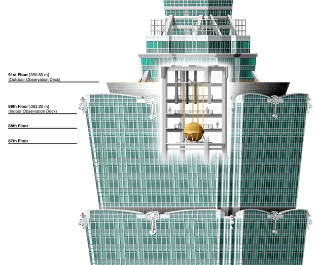 The damper ball is visible between the 89th and 91st floor of Taipei 101 and has become an attraction for tourists.  Sneed B. Collard III is author of more than eighty award-winning children’s books as well as a new book for educators, Teaching Nonfiction Revision: A Professional Writer Shares Strategies, Tips, and Lessons. Sneed is a dynamic speaker and offers school and conference programs that combine science, nature, and literacy. To learn more about him and his talks, visit his website,. To learn more about the damper ball and watch how it performed during Typhoon Soudelor, check out this article and video: http://www.thorntontomasetti.com/taipei-101s-tmd-explained/ MLA 8 Citation Collard, Sneed B. "Damping Down Danger." Nonfiction Minute, iNK Think Tank, 10 01 2018, www.nonfictionminute.org/the-nonfiction-minute/ Damping-Down-Danger.  
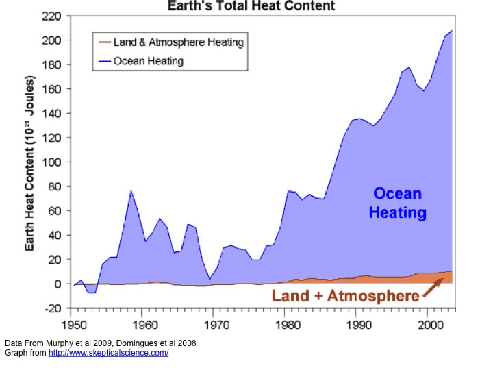
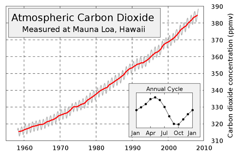
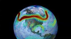 The polar jet stream can travel at speeds greater than 100 miles per hour (160 km/h). Here, the fastest winds are colored red; slower winds are blue. NASA/Goddard Space Flight Center The polar jet stream can travel at speeds greater than 100 miles per hour (160 km/h). Here, the fastest winds are colored red; slower winds are blue. NASA/Goddard Space Flight Center No one can honestly deny that our climate has been changing in recent years. Before the winter of 2018-2019, California had only a year’s water supply stored in its reservoirs. Wildfires have become an annual threat throughout much of the west, while the Midwest and East Coast have experienced record-setting winters. These problems are due to complex interactions among temperature, winds, and water currents. A major change is the warming of the atmosphere. The earth’s atmosphere has been getting warmer since the late 1800s, when factories started spewing out carbon dioxide. Because natural variations also affect the temperature, a graph showing the temperature over time is a jagged line. But the trend is consistently upward and follows the graph of increasing carbon dioxide in the atmosphere due to human activities. That’s strong enough evidence that we are at least a large part of the problem, and the vast majority of climate scientists are urging countries of the world to reduce their carbon dioxide emissions. A major player in the world’s weather is the jet stream, which helps circulate the atmosphere around the world about every two weeks. This flow of fast-moving air speeds across North America from west to east, separating cold arctic air from warmer, more southerly air. The jet stream used to run in a fairly direct arc across the northern United States. But in recent years it has become less stable, dipping southward in the eastern U.S. to bring frigid winters to the Northeast while arching northward in the West, carrying warm, dry air there. Scientists believe that the rapid melting of the Arctic ice brought about by global warming is part of the cause for the jet stream’s instability. However, climate trends are controlled more by the oceans. Scientists estimate 95% of the heat from global warming is being stored in the oceans, increasing water temperatures even into the depths. As global warming continues, so will climate change. The melting of sea ice and glaciers is already raising the sea level. While scientists don’t blame climate change for devastating Hurricane Sandy, Sandy’s extreme coastal flooding was made worse by the increase in sea level that’s already occurred. As time goes on, coastal cities around the world will be at increasing risk for more severe storm damage. Because warm air holds more moisture than cold air, storms are becoming more severe, increasing blizzards and flooding storms. Some agricultural regions that depend on reliable rainfall may soon be unable to grow crops, disrupting the food supply. Climate change is complicated, but because it affects us all, we need to learn about it. The Environment Protection Agency has questions and answers about climate change.
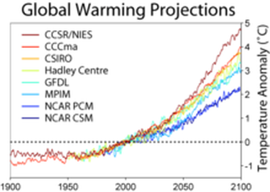 Calculations of global warming prepared in or before 2001 from a range of climate models. The projections assume no action is taken to reduce emissions. 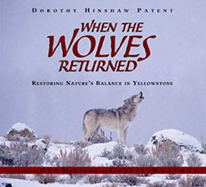 Yellowstone National Park’s majestic geologic wonders and remarkable wildlife draw millions of visitors each year. But there was a time when these natural treasures were in great danger, all because after years of unrestricted hunting, one key piece of the puzzle had been eliminated—the wolf. Now, more than a decade after scientists realized the wolves’ essential role and returned them to Yellowstone, the park’s natural balance is gradually being restored. Dorothy Hinshaw Patent's text supplemented by spectacular full-color photographs show the wolves in the natural habitat that was almost lost without them. Click here to find out more. Dorothy Hinshaw Patent is a member of iNK's Authors on Call and is available for classroom programs through Field Trip Zoom, a terrific technology that requires only a computer, wifi, and a webcam. Click here to find out more. MLA 8 Citation Patent, Dorothy Hinshaw. "Climate Change: The Facts and the Consequences." Nonfiction Minute, iNK Think Tank, 17 Apr. 2018, www.nonfictionminute.org/the-nonfiction-minute/ Climate-Change-The-Facts-and-the-Consequences. 
Earth has a problem. The sun creates hot spots over land, in the air and in the water. That’s why there are winds, weather, and currents in the ocean as Earth tries to even out the heat, moving warmer masses of air and water to cooler areas. During hurricane season ( from June 1-November 30), only 10 or 11 of the 80 tropical disturbances off the west coast of Africa (where most of our hurricanes originate) become large enough storms to be given a name. Only two or three of them hit the United States. They are not frequent but they are massive wind storms that can destroy life and property. Do they do anything good at all? As far as the Earth is concerned, these largest of all storms are a safety valve to rapidly move heat that has been accumulating in the oceans up to the stratosphere (from 7 to 31 miles above the Earth’s surface). From there it will be transported through the air to over the North Pole. It’s the way Earth stops a fever. Once a hurricane forms, it must have an ocean surface that is at least 80°F to keep moving and to grow. Under the storm, huge amounts of warm water become water vapor. Warm moist air rapidly rises through the spinning winds of the hurricane, up to the stratosphere. When moist air reaches the frigid (-70°F) stratosphere the water vapor quickly condenses to liquid water (rain) releasing its heat. This heat makes surrounding air molecules move faster forming winds. How do hurricanes cool off the oceans? How do they move the heat? Here’s a clue: Wet your finger and wave it in the air. How does it feel? Pretty cool, I bet! That’s because the heat from your finger changes liquid water into water vapor (a gas) as your finger dries. Water vapor molecules store this extra heat. They rise because they are lighter than other air molecules. So, a hurricane is a heat engine that moves water vapor from the ocean’s surface high enough to condense back into liquid water and release heat safely to the stratosphere forming rivers of wind that move it to the poles. Scientists predict that global warming will increase the number and the power of the hurricanes as the ocean surfaces become increasingly warmer during our summers. 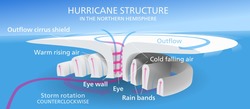 This diagram of the anatomy of a hurricane shows the direction of the winds. The blue represents cold air descending while the pink shows warm moist air rising. The outflow surface clouds form as water condenses into a "table-top" cloud, releasing heat that becomes wind. Kelvinsong via Wikimedia 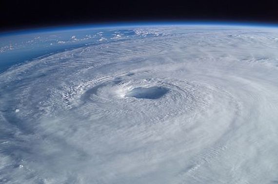 Hurricane Isabel (2003) as seen from orbit during Expedition 7 of the International Space Station. The eye, eyewall, and surrounding rainbands, all characteristics of hurricanes, are clearly visible in this view from space. Image courtesy of Mike Trenchard, Earth Sciences & Image Analysis Laboratory, NASA Johnson Space Center 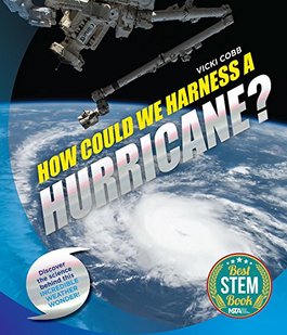 Vicki Cobb's How Could We Harness a Hurricane? offers questions and provides new points of view that may just change peoples' thinking by showing young readers the work scientists and engineers are doing to avoid future disasters. The book includes hands-on experiments that make science fun, be it at home or in the classroom. Here's a link to the book' s Trailer. How Could We Harness a Hurricane was named a 2018 Best STEM Book K-12 by the National Science Teachers Association and the Children's Book Council. Vicki is a member of iNK's Authors on Call so you can invite her to your classroom via iNK's videoconferening Zoom Room. Click here to find out more: MLA 8 Citation Cobb, Vicki. "Earth's Emergency Heat Valve: The Hurricane." Nonfiction Minute, iNK Think Tank, 24 Apr. 2018, www.nonfictionminute.org/ the-nonfiction-minute/Earths-Emergency-Heat-Valve-The-Hurricane.  |
*NEWS
|


 RSS Feed
For Vicki Cobb's BLOG (nonfiction book reviews, info on education, more), click here: Vicki's Blog
The NCSS-CBC Notable Social Studies Committee is pleased to inform you
that 30 People Who Changed the World has been selected for Notable Social Studies Trade Books for Young People 2018, a cooperative project of the National Council for the Social Studies (NCSS) & the Children’s Book Council
Categories
All
Abolitionists
Adams Janus
Adaptation
Adaptations
Adkins Jan
Advertising
Aerodynamics
Africa
African American History
African Americans
Africa West
Agriculture
Aircraft
Air Pilots
Air Pressure
Air Travel
Albee Sarah
Alchemy
Alligators
Allusion
American History
American Icons
Amphibians
Amundsen Roald
Anatomy
Ancient
Ancient Cultures
Anderson Marian 1897-1993
Animal Behavior
Animal Experimentation
Animal Intelligence
Animals
Animation
Antarctica
Ants
Apache Indians
Apes
April Fool's Day
Architecture
Argument
Arithmetic
Art
Art Deco
Artists
Arts
Asia
Astronauts
Astronomy
Athletes
Atomic Theory
Audubon Societies
Authors
Autobiography
Automobiles
Aviation
Awards
Bacteria
Baseball
Battuta Ibn
Bears
Beatles
Beavers
Bees
Biodegradation
Biography
Biology
Biomes
Biomimicry
Biplanes
Birds
Black Death
Black History
Blindness
Blizzards
Bombs
Bonaparte Napoleon
Boone Daniel
Botany
Brazil
Bridges
Brill Marlene Targ
Brooklyn Bridge
Brown John
Buffaloes
Building Materials
Butterflies
Caesar
Caesar Julius
Caissons
Calculus
Calendars
Cannibal
Capitals
Caravaggio
Carbon Dioxide
Carnivores
Carson Mary Kay
Cartoons & Comics
Carving (Decorative Arts)
Cascade Range
Castaldo Nancy
Castles
Castrovilla Selene
Cathedrals
Cats
Caves
Celts
Cemeteries
Chemistry
Children's Authors
Child Welfare
China
Choctaw Indians
Christmas
Chronometers
Cicadas
Cinco De Mayo
Ciphers
Circle
Citizenship
Civil Rights
Civil Rights Movements
Civil War
Civil War - US
Climate
Climate Change
Clocks And Watches
Clouds
Cobb Vicki
COBOL (Computer Language)
Code And Cipher Stories
Collard III Sneed B.
Collectors And Collecting
Color
Commerce
Communication
Competition
Compilers
Composers
Computers
Congressional Gold Medal
Consitution
Contests
Contraltos
Coolidge Calvin
Cooling
Corms
Corn
Counterfeiters
Covid-19
Crocodiles
Cryptography
Culture
Darwin Charles
Declaration Of Independence
Decomposition
Decompression Sickness
Deep-sea Animals
Deer
De Medici Catherine
Design
Detectives
Dickens Charles
Disasters
Discrimination
Diseases
Disney Walt
DNA
Dogs
Dollar
Dolphins
Douglass Frederick 1818-1895
Droughts
Dr. Suess
Dunphy Madeleine
Ear
Earth
Earthquakes
Ecology
Economics
Ecosystem
Edison Thomas A
Education
Egypt
Eiffel-gustave-18321923
Eiffel-tower
Einstein-albert
Elephants
Elk
Emancipationproclamation
Endangered Species
Endangered-species
Energy
Engineering
England
Englishlanguage-arts
Entomology
Environmental-protection
Environmental-science
Equinox
Erie-canal
Etymology
Europe
European-history
Evolution
Experiments
Explorers
Explosions
Exports
Extinction
Extinction-biology
Eye
Fairs
Fawkes-guy
Federalgovernment
Film
Fires
Fishes
Flight
Floods
Flowers
Flute
Food
Food-chains
Foodpreservation
Foodsupply
Food-supply
Football
Forceandenergy
Force-and-energy
Forensicscienceandmedicine
Forensic Science And Medicine
Fossils
Foundlings
France
Francoprussian-war
Freedom
Freedomofspeech
French-revolution
Friction
Frogs
Frontier
Frontier-and-pioneer-life
Frozenfoods
Fugitiveslaves
Fultonrobert
Galapagos-islands
Galleys
Gametheory
Gaudi-antoni-18521926
Gender
Generals
Genes
Genetics
Geography
Geology
Geometry
Geysers
Ghosts
Giraffe
Glaciers
Glaucoma
Gliders-aeronautics
Global-warming
Gods-goddesses
Gold-mines-and-mining
Government
Grant-ulysses-s
Grasshoppers
Gravity
Great-britain
Great-depression
Greece
Greek-letters
Greenberg Jan
Hair
Halloween
Handel-george-frederic
Harness Cheryl
Harrison-john-16931776
Health-wellness
Hearing
Hearing-aids
Hearst-william-randolph
Henry-iv-king-of-england
Herbivores
Hip Hop
History
History-19th-century
History-france
History-world
Hitler-adolph
Hoaxes
Holidays
Hollihan Kerrie Logan
Homestead-law
Hopper-grace
Horses
Hot Air Balloons
Hot-air-balloons
Housing
Huguenots
Human Body
Hurricanes
Ice
Icebergs
Illustration
Imagery
Imhotep
Imperialism
Indian-code-talkers
Indonesia
Industrialization
Industrial-revolution
Inquisition
Insects
Insulation
Intelligence
Interstatecommerce
Interviewing
Inventions
Inventors
Irrational-numbers
Irrigation
Islands
Jacksonandrew
Jazz
Jeffersonthomas
Jefferson-thomas
Jemisonmae
Jenkins-steve
Jet-stream
Johnsonlyndonb
Jokes
Journalism
Keeling-charles-d
Kennedyjohnf
Kenya
Kidnapping
Kingmartinlutherjr19291968
Kingmartinlutherjr19291968d6528702d6
Kings-and-rulers
Kings Queens
Kings-queens
Koala
Labor
Labor Policy
Lafayette Marie Joseph Paul Yves Roch Gilbert Du Motier Marquis De 17571834
Landscapes
Languages-and-culture
Law-enforcement
Layfayette
Levers
Levinson Cynthia
Lewis And Clark Expedition (1804-1806)
Lewis Edmonia
Liberty
Lift (Aerodynamics)
Light
Lindbergh Charles
Liszt Franz
Literary Devices
Literature
Lizards
Longitude
Louis XIV King Of France
Lumber
Lunar Calendar
Lynching
Macaws
Madison-dolley
Madison-james
Madison-james
Mammals
Maneta-norman
Maneta-norman
Marathon-greece
Marine-biology
Marine-biology
Marines
Marsupials
Martial-arts
Marx-trish
Mass
Massachusetts-maritime-academy
Mass-media
Mastodons
Mathematics
May-day
Mcclafferty-carla-killough
Mcclafferty-carla-killough
Mckinley-william
Measurement
Mechanics
Media-literacy
Media-literacy
Medicine
Memoir
Memorial-day
Metaphor
Meteorology
Mexico
Mickey-mouse
Microscopy
Middle-west
Migration
Military
Miners
Mississippi
Molasses
Monarchy
Monsters
Montgomery
Montgomery-bus-boycott-19551956
Montgomery-heather-l
Monuments
Moon
Moran-thomas
Morsecode
Morsesamuel
Moss-marissa
Moss-marissa
Motion
Motion-pictures
Mummies
Munro-roxie
Munro-roxie
Musclestrength
Museums
Music
Muslims
Mythologygreek
Nanofibers
Nanotechnology
Nathan-amy
Nathan-amy
Nationalfootballleague
Nationalparksandreserves
Nativeamericans
Native-americans
Native-americans
Naturalhistory
Naturalists
Nature
Nauticalcharts
Nauticalinstruments
Navajoindians
Navigation
Navy
Ncaafootball
Nervoussystem
Newdeal19331939
Newman-aline
Newman-aline
Newton-isaac
New-york-city
Nobelprizewinners
Nomads
Nonfictionnarrative
Nutrition
Nylon
Nymphs-insects
Oaths Of Office
Occupations
Ocean
Ocean-liners
Olympics
Omnivores
Optics
Origami
Origin
Orphans
Ottomanempire
Painters
Painting
Paleontology
Pandemic
Paper-airplanes
Parksrosa19132005
Parrots
Passiveresistance
Patent Dorothy Hinshaw
Peerreview
Penguins
Persistence
Personalnarrative
Personification
Pets
Photography
Physics
Pi
Pigeons
Pilots
Pinkertonallan
Pirates
Plague
Plains
Plainsindians
Planets
Plantbreeding
Plants
Plastics
Poaching
Poetry
Poisons
Poland
Police
Political-parties
Pollen
Pollution
Polo-marco
Populism
Portraits
Predation
Predators
Presidentialmedaloffreedom
Presidents
Prey
Prey-predators
Prey-predators
Prime-meridian
Pringle Laurence
Prohibition
Proteins
Protestandsocialmovements
Protestants
Protestsongs
Punishment
Pyramids
Questioning
Radio
Railroad
Rainforests
Rappaport-doreen
Ratio
Reading
Realism
Recipes
Recycling
Refrigerators
Reich-susanna
Religion
Renaissance
Reproduction
Reptiles
Reservoirs
Rheumatoidarthritis
Rhythm-and-blues-music
Rice
Rivers
Roaringtwenties
Roosevelteleanor
Rooseveltfranklind
Roosevelt-franklin-d
Roosevelt-theodore
Running
Russia
Safety
Sanitation
Schwartz David M
Science
Scientificmethod
Scientists
Scottrobert
Sculpture
Sculpturegardens
Sea-level
Seals
Seals-animals
Secretariesofstate
Secretservice
Seeds
Segregation
Segregationineducation
Sensessensation
September11terroristattacks2001
Seuss
Sextant
Shackletonernest
Shawneeindians
Ships
Shortstories
Silkworms
Simple-machines
Singers
Siy Alexandra
Slavery
Smuggling
Snakes
Socialchange
Social-change
Socialjustice
Social-justice
Socialstudies
Social-studies
Social-studies
Sodhouses
Solarsystem
Sound
Southeast-asia
Soybean
Space Travelers
Spain
Speech
Speed
Spiders
Spies
Spiritualssongs
Sports
Sports-history
Sports-science
Spring
Squirrels
Statue-of-liberty
STEM
Storms
Strategy
Sugar
Sumatra
Summer
Superbowl
Surgery
Survival
Swanson-jennifer
Swinburne Stephen R.
Synthetic-drugs
Taiwan
Tardigrada
Tasmania
Tasmanian Devil
Tasmanian-devil
Technology
Tecumsehshawneechief
Telegraph-wireless
Temperature
Tennis
Terrorism
Thomas Peggy
Thompson Laurie Ann
Time
Titanic
Tombs
Tortoises
Towle Sarah
Transcontinental-flights
Transportation
Travel
Trees
Trung Sisters Rebellion
Tundra
Turnips
Turtles
Typhoons
Underground Railroad
Us-environmental-protection-agency
Us History
Us-history
Ushistoryrevolution
Us History Revolution
Us-history-war-of-1812
Us Presidents
Ussupremecourtlandmarkcases
Vacations
Vaccines
Vangoghvincent
Vegetables
Venom
Vietnam
Viruses
Visual-literacy
Volcanoes
Voting-rghts
War
Warne-kate
Warren Andrea
Washington-dc
Washington George
Water
Water-currents
Wax-figures
Weapons
Weather
Weatherford Carole Boston
Whiting Jim
Wildfires
Winds
Windsor-castle
Wolves
Woman In History
Women
Women Airforce Service Pilots
Women-airforce-service-pilots
Womeninhistory
Women In History
Women-in-science
Women's History
Womens-roles-through-history
Wonder
Woodson-carter-godwin-18751950
World-war-i
World War Ii
World-war-ii
Wright Brothers
Writing
Writing-skills
Wwi
Xrays
Yellowstone-national-park
Zaunders Bo
ArchivesMarch 2021
February 2021
January 2021
December 2020
November 2020
October 2020
September 2020
June 2020
May 2020
April 2020
March 2020
February 2020
January 2020
December 2019
October 2019
September 2019
August 2019
July 2019
May 2019
April 2019
March 2019
February 2019
January 2019
December 2018
November 2018
September 2018
June 2018
May 2018
April 2018
March 2018
February 2018
January 2018
December 2017
November 2017
October 2017
September 2017
March 2017
The NONFICTION MINUTE, Authors on Call, and. the iNK Books & Media Store are divisions of iNK THINK TANK INC.
a 501 (c) (3) nonprofit corporation. To return to the iNK Think Tank landing page click the icon or the link below. :
http://inkthinktank.org/
For more information or support, contact thoughts@inkthinktank.org
For Privacy Policy, go to
Privacy Policy
© COPYRIGHT the Nonfiction Minute 2020.
ALL RIGHTS RESERVED.
This site uses cookies to personalize your experience, analyze site usage, and offer tailored promotions. www.youronlinechoices.eu
Remind me later
Archives
March 2023
February 2023
January 2023
December 2022
November 2022
October 2022
September 2022
June 2022
May 2022
April 2022
March 2022
February 2022
January 2022
December 2021
November 2021
September 2021
April 2021
March 2021
February 2021
November 2020
October 2020
September 2020
June 2020
May 2020
April 2020
March 2020
February 2020
January 2020
October 2019
August 2019
July 2019
May 2019
April 2019
December 2018
September 2018
June 2018
May 2018
March 2018
February 2018
January 2018
December 2017
November 2017
October 2017
September 2017